Loading...
Loading...
The Expedition Map
August 17, 2026 at 03:59 PM
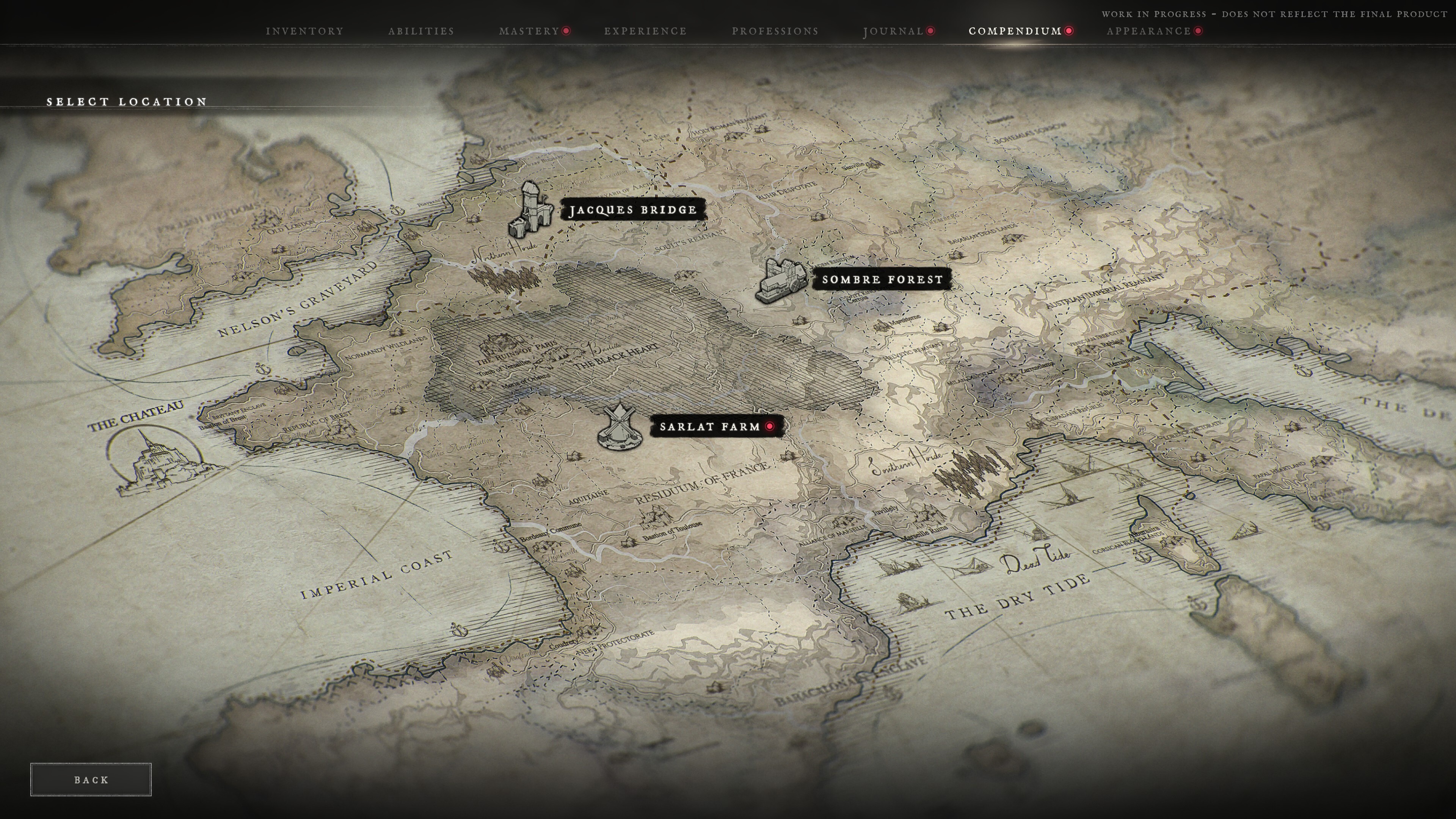
Embedded the official Expedition Map Select Location capture showing the world chart and the three pinned launch destinations
The Expedition Map is the screen a party uses to leave The Chateau and commit to a run into the mainland. It is reached through Reynauld's map, and it is the gateway to every Expedition the game offers. Whether a survivor sets out alone or alongside one or two companions, the journey begins here.
The map presents the locations currently open to the party under a Select Location prompt. The three launch destinations, Sombre Forest, Jacques Bridge and Sarlat Farm, are pinned onto a hand-drawn chart of the ruined continent, with the Chateau itself marked on the north-western coast as an island abbey ringed by water.
Only the party leader may choose an Expedition and commit the group to a destination. Everyone else in the party is carried along with that choice, which makes the leader's read on the group's readiness part of the decision.
Once a destination is selected, matchmaking begins quietly in the background rather than locking the party into a loading screen. Players stay free to move around the Chateau while they wait: visiting Vendors, reorganising the Stash, crafting equipment, or talking to the hub's residents. The waiting screen reports the destination alongside the conditions the run will use, in the form of a location name, a time of day and a weather state, and it counts up the time elapsed while a route is found.
When a match is found, a ten-second countdown begins. When it reaches zero the party departs together and there is no turning back, so the last few seconds before a run are the final chance to reconsider a loadout.
No two journeys are quite the same. Every Expedition runs under its own conditions: one may begin beneath a clear morning sky, another under heavy rain, dense fog, or full darkness. At launch the rotation is used primarily to vary these environmental conditions, so a familiar location can feel unfamiliar simply because of the weather and the hour it is played in.
Available Expeditions rotate across three different durations. All three refresh together on the hour, producing a selection of journeys that keeps shifting through the day. Some destinations stay open for long stretches, while others surface only briefly before disappearing again.
Route Length | Behaviour |
|---|---|
12-hour routes | The longest-lived entries on the board, open across most of a play session |
3-hour routes | A mid-length window that turns over several times a day |
1-hour routes | The shortest window, present only briefly before it rotates out |
The studio has said that as the game grows, destinations themselves will rotate rather than every location staying permanently available. The stated reasons are to keep matchmaking healthy and to make each Expedition on the board feel worth taking. Rotation is also the hook for changing faction occupations, roaming mini-bosses, world modifiers and seasonal events, so the mainland is meant to shift from one day to the next rather than sitting still.
The Expedition Map is intended to become the launching point for everything beyond a standard run. As new systems arrive, boss encounters, Trials, other player-versus-environment activities, seasonal events and future game modes are all planned to appear here, making the map the single place a player goes to find whatever the world has open at that moment.
The chart covers far more of the continent than the three playable destinations. Its labels sketch out a Europe broken into remnant states, occupied zones and dead ground, and they are a rare look at the wider setting outside the maps players can currently visit. These names are cartography rather than selectable content: only the pinned Expeditions can be entered.
Region | Where It Sits on the Chart |
|---|---|
Nelson's Graveyard | The northern sea between the Chateau coast and the English side of the channel |
English Fiefdoms | The British landmass to the north-west, including a marked Old London |
Imperial Coast | The western ocean along the Atlantic seaboard |
Normandy Wildlands | Northern France, inland from the coast |
Brittany Enclave and the Republic of Brest | The western peninsula, with a Bastion of Brest marked |
The Ruins of Paris | The old capital, shown alongside a Tomb of Versailles and a Bastille |
The Black Heart | A heavily shaded zone east of Paris |
Residuum of France | The surviving French interior, where Sarlat Farm is pinned |
Aquitaine, Bordeaux Commune and the Bastion of Toulouse | The south-west |
Soult's Remnant and the Holy Roman Remnant | The north-east, toward the German states |
Ruhr Despotate and Baden Residuum | The Rhine country, near where Sombre Forest is pinned |
Ashes of Nuremberg and the Bavarian Dead Lands | Southern Germany |
Bohemian Cordon | The eastern frontier |
Austrian Imperial Remnant | The eastern Alps and beyond |
Helvetic Remnant | The Alpine centre |
Milanese Despotate, Venetian Free Cities, Cispadane Republic and Florence Protectorate | The Italian peninsula |
Northern Horde and Southern Horde | Two named masses of the infected, drawn in script across the north and the south-east |
Two of those labels are worth singling out. The Northern Horde and Southern Horde are not territories but concentrations of the infected, written across the chart the way a cartographer would mark a hazard rather than a border. Their placement is the clearest indication yet of how the plague is distributed across the continent.