
Loading...
Loading...
Roads and Highways
November 21, 2026 at 12:45 AM
Created Roads and Highways hub: interstates, U.S. routes, state and county routes and Vice City streets from the official map and trailer road signs, with where each runs in the game
Leonida's road network links Vice City with the rest of the state. Rockstar's official map of Leonida, released as a free poster on launch day (November 19, 2026), marks the main routes with shields: interstates, U.S. routes, a state route down the keys and a county route, with a separate toll shield in its legend. Many city streets were first seen on road signs in the Trailers and in An Extended Look. This page lists each named road, where Rockstar shows it, and where it runs in the game. Interstate 404 has its own page.
Road | Official map and trailers | In the game |
|---|---|---|
Interstate 97 | Four shields on the official map, from the northeast coast below Richard Barebone State Park, east of the Leonard County label, beside La Perle and down to the west of Tequesta. About 0:38 into the second trailer, a sign reads North, Port VC, with shields for 97 and 397 and the word Downtown. In the first trailer, the Interstate 404 sign for Kelly County reads "to 97". | Crosses Vice City on bridges: between Little Cuba and Downtown, on the Tequesta and Salton border, and over parts of Crosstown, La Perle and Bayside. Ramps link it to US-10 in La Perle. Further north it passes Belville, Hamlet and Waning Sands, and a new bridge is under construction where it crosses Richard Barebone State Park. |
Interstate 297 | Two shields across the north of the state, south of Mount Kalaga National Park: one west of North Kelly County, the other by North Leonard County. | Runs through North Kelly County, where Moonstone Hwy meets it, past Tallaloko Lake Rd in North Leonard County, and through northwestern East Lummox County and northwestern Waning Sands. |
Interstate 397 | One shield on the official map, just south of Downtown and northwest of the large Vice-Dale County label. It shares the second trailer's North, Port VC sign with Interstate 97. | Known from the map shield and the trailer sign (November 2026). |
About 0:24 into the first trailer, its sign points to Kelly County and VCI Airport. In An Extended Look (about 13:06), Exit 21B marks where 404 ends. | Crosses U.S. 35 on an overpass in Salton and passes Port Gellhorn, West Vice-Dale County and South Kelly County. |
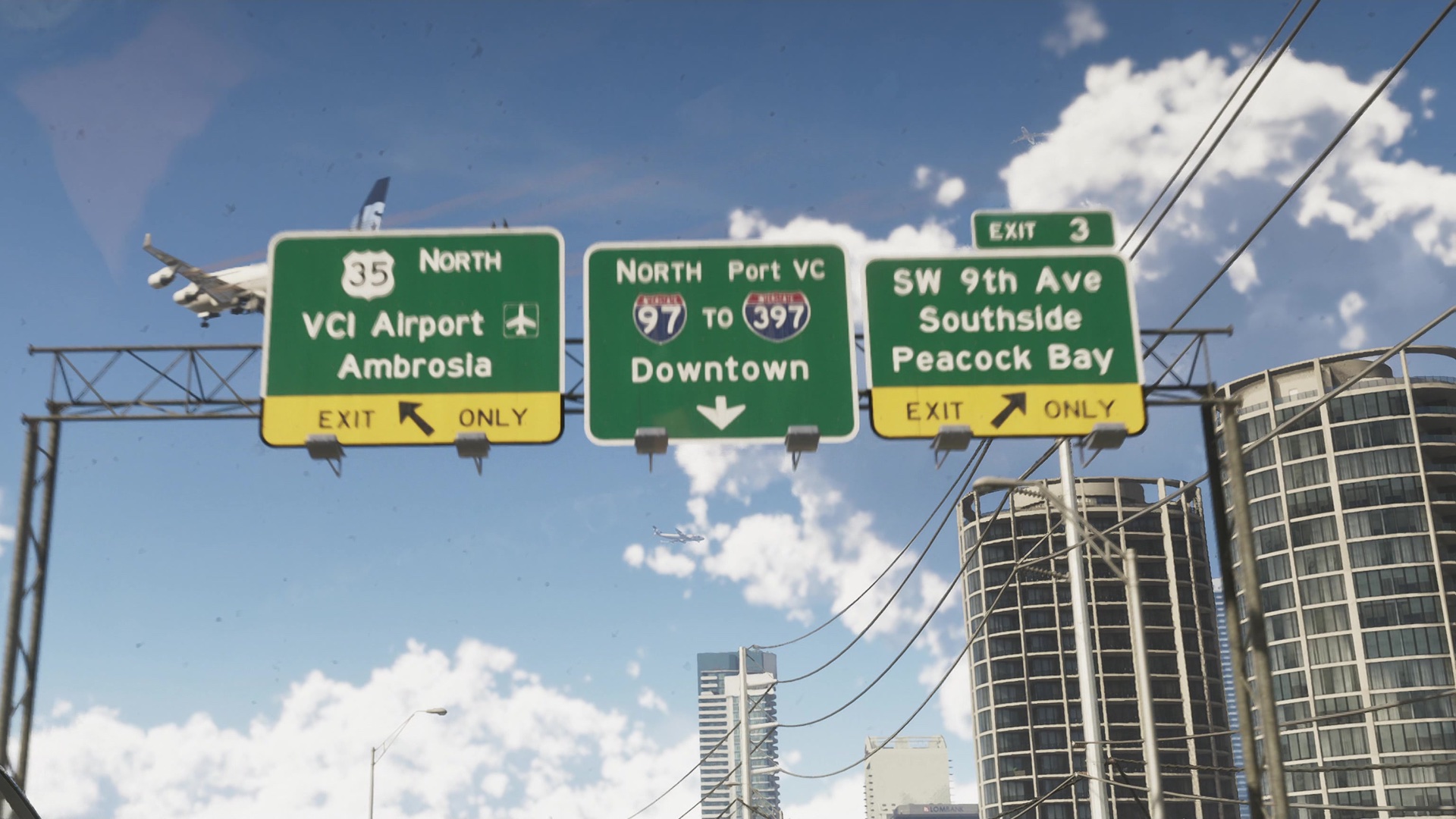
The second trailer's three overhead signs, about 0:38 in, show three routes at once: U.S. 35 North to VCI Airport and Ambrosia on the left, Interstates 97 and 397 north to Port VC and Downtown in the middle, and Exit 3 for SW 9th Ave, Southside and Peacock Bay on the right. The released map names the port Port Vice City.
Road | Official map and trailers | In the game |
|---|---|---|
U.S. 35 | Four shields, north to south: northeast of Ambrosia Raceway Park, south of the Allied Crystal Sugar Refinery, beside the Tisha-Wocka Flea Market and beside Southside. Signed 35 North to VCI Airport and Ambrosia in the second trailer. | Runs through northern Ambrosia, where the Big Day Motel stands on it, over a broken bridge on the border of Ambrosia and Emerald Springs, through North Kelly County, across the river in Balsero, past the eastern edge of Vice City International Airport and under Interstate 404 in Salton. |
U.S. 82 | One shield in the southwest, southwest of Breakwater Quarry and just north of Big Pine. | Passes through Grassrivers, by the Mariana County Sheriff's Office, and along the border of North Mariana County. In eastern Hamlet it crosses Calderone Ave on a bridge and meets Emory Ave. |
U.S. 183 | Two shields in the west: one beside Capri and Tortoise Lake, the other beside Leonida State Prison. | Runs past southeastern Capri, through Port Gellhorn, where construction sites beside it hold Stunt Jumps, and through South Kelly County, where Interstate 404 crosses it. King Gator Adventure Golf's sign stands in its median. |
U.S. 628 | Two shields across the north: one beside Grayson in the northwest, the other east of Moreau near the Tallaloko Lakeside Resort. | Runs through Moreau, past the Dock Coal Company, through Millport and East Lummox County, and along the border of South West Lummox County and Mount Kalaga National Park. |
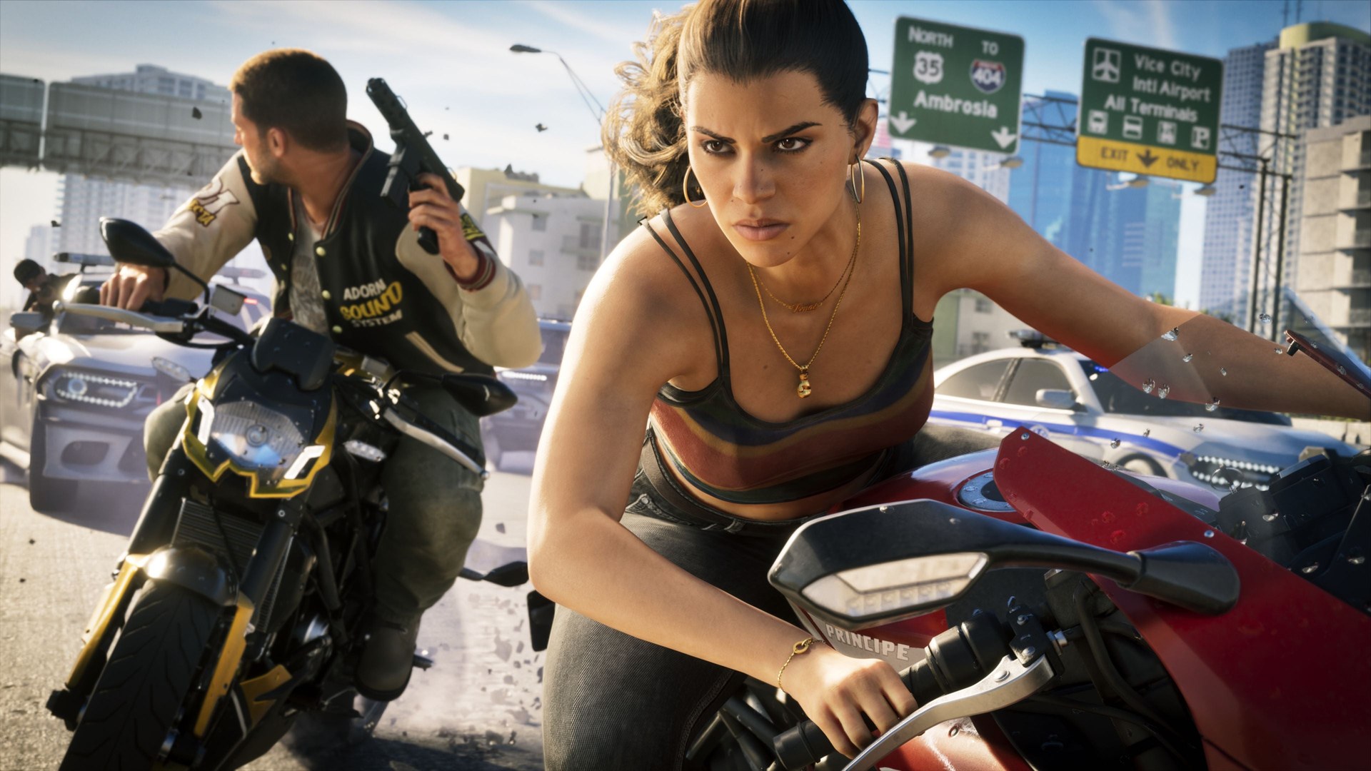
An official screenshot released at launch shows Jason and Lucia on motorcycles under an overhead sign for North 35, to Interstate 404 and Ambrosia, beside a sign for Vice City Intl Airport.
Road | Official map | In the game |
|---|---|---|
State Route 1A | Its shield shows a dolphin over the number. It runs down the keys from Catalan Key south past Key Lento to Southwind. North of Key Lento, beside the Shoeless Keys, the map gives it the toll shield instead: Toll over the same dolphin and 1A. | Bridges along the keys include the Keylime Causeway between Abismo Key and Key Lento, and the abandoned Saltrock and Key Lento bridges, which carry Stunt Jumps. |
County Route 62 | Two shields: one southeast of Port Gellhorn, one between Ambrosia and Belville. Each reads Dale County around the number, like the county route shield in the map's legend. | Passes the Howe Dairy Farm in northern Emerald Springs, a campsite and a radio tower in the Gellhorn area, and runs under U.S. 183 in Port Gellhorn and under Interstate 97 in Belville, continuing into South Leonard County. |
Road | Where Rockstar shows it | In the game |
|---|---|---|
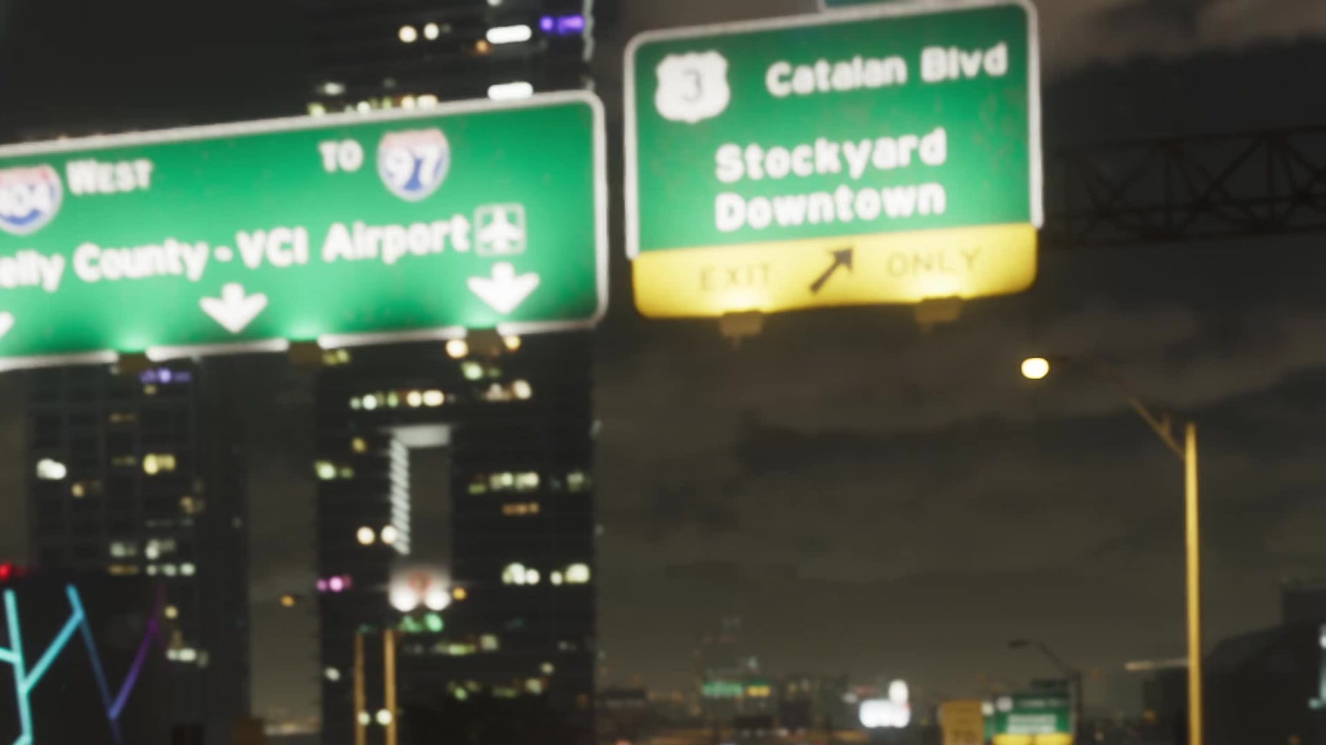
Catalan Boulevard | About 0:24 into the first trailer, a night sign reads Catalan Blvd beside a U.S. 3 shield, with Stockyard and Downtown below it, next to the Interstate 404 sign for Kelly County. | Runs through southern Downtown at Mariner's Hwy, Tequesta, Bayside, the Decor District and Waning Sands. Its bridge over the canal between Tequesta and Downtown has a control tower. |
Mirimar Drive | A Mirimar Dr street sign hangs over an intersection about 8:43 to 8:46 into An Extended Look, beside freeway signs for the Rialto Islands. | Runs through Crosstown, La Perle and southern Bayside, where it meets Rialto Cswy. |
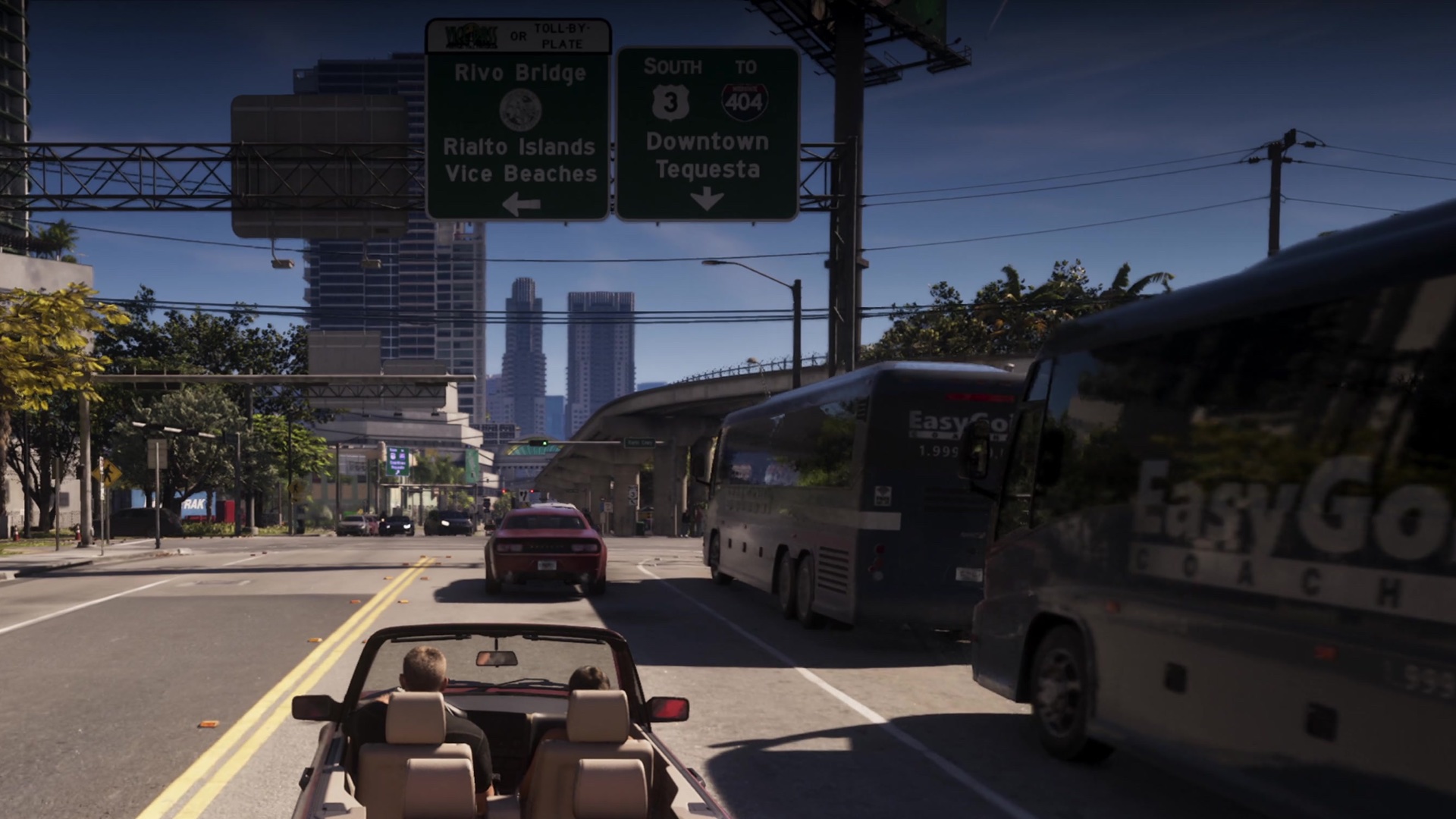
Rivo Bridge | About 8:39 into An Extended Look, a sign topped with a toll notice (pay by pass or toll by plate) reads Rivo Bridge above the state seal, with the Rialto Islands and Vice Beaches to the left. | Crosses the water between Catalan Island and Bayside; it is one of the Under the Bridge flights. |
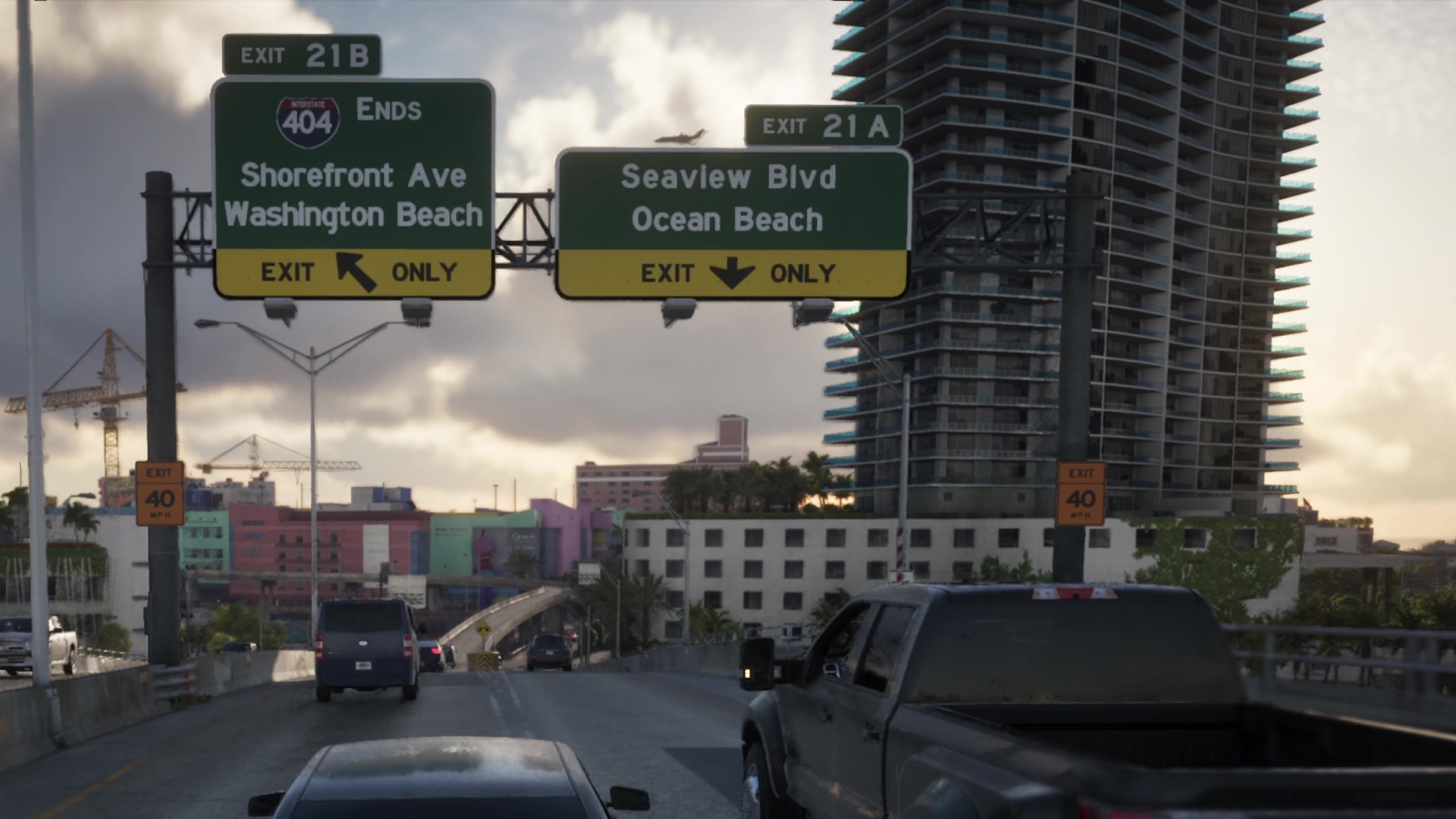
Seaview Boulevard | Exit 21A, signed Seaview Blvd and Ocean Beach, about 13:06 into An Extended Look. | A street in Ocean Beach; it meets Shore Dr by the Hathaway Apartments. |
Shorefront Avenue | Exit-only signs on Interstate 404 read Shorefront Ave and Washington Beach about 12:52 into An Extended Look; a later sign marks it as Exit 21B, where 404 ends. | A shopping street in Ocean Beach, with stores such as Josefina Perfect Image and Dream Shoes. |
Shore Drive | Rockstar's Ultimate Edition description of the '95 Grotti Cheetah calls the car Grotti's signature mid '90s sports car and "ode to Shore Drive". Rockstar has not said where Shore Drive is. | A street named Shore Dr runs through Ocean Beach, past the Atlantis Hotel, the Positano Towers and the Banana Hole bar. |
SW 4th Street | An SW 4th St sign hangs at an intersection beside a curved white Hobbs Milford building about 18:05 into An Extended Look. | Crosses western Tequesta, Oldby Island, Washington Beach, where it bridges the river, and southern Salton. |
SW 9th Avenue | First name on the Exit 3 sign, above Southside and Peacock Bay, about 0:38 into the second trailer. | Runs through northern Southside; a RON gas station stands at its corner with El Joven Blvd. |
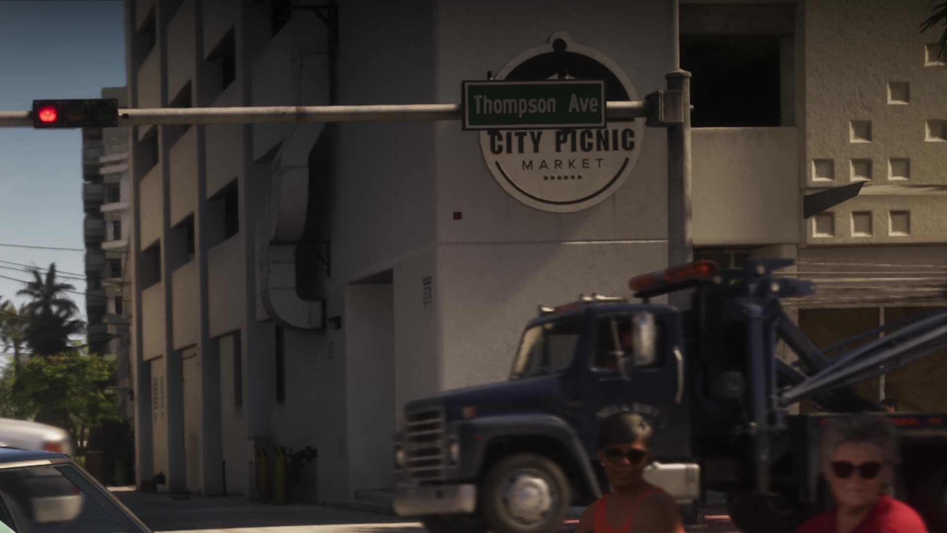
Thompson Avenue | A Thompson Ave sign hangs at a traffic light in front of a City Picnic Market sign, as a tow truck passes, about 15:47 into An Extended Look. | Runs through Ocean Beach and Vice Beach. The City Picnic Market parking garage at Thompson Ave and D St holds one of the Stunt Jumps. |
The night sign for Catalan Boulevard hangs beside the Interstate 404 sign for Kelly County and VCI Airport, early in the first trailer.
In An Extended Look the Rivo Bridge toll sign hangs beside a second sign for Downtown and Tequesta, with coach buses on the road ahead.
Near the end of Interstate 404, the exits split between Shorefront Ave for Washington Beach and Seaview Blvd for Ocean Beach.
Thompson Avenue's street sign is seen in front of the City Picnic Market, the same store whose parking garage hosts a stunt jump in the game.
These roads are named in the game but not marked with shields on the official map.
Road | Where it runs |
|---|---|
Sunbelt Hwy | Through Key Lento and Abismo Key in the keys. |
Mariner's Hwy | Southeastern Downtown, where it meets Catalan Blvd by a park. |
US-10 | Ramps from Interstate 97 in La Perle, and a ramp to U.S. 35 between Balsero and Buckskin Swamp. |
SR-25 | Bridges over the river in Little Cuba and in Balsero. |
SR-27 | North Kelly County, under U.S. 35. |
Moonstone Hwy | North Kelly County, where it meets Interstate 297. |
Rialto Cswy | Southern Bayside, meeting Mirimar Dr. |